
Simonds Rock
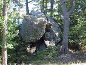 Simonds Rock is a natural wonder of Merrimack. It is a glacial erratic formation located near Pennichuck Brook. This jumbled heap of boulders was left behind when the glacier that covered New Hampshire receded between 12,000 to 16,000 years ago. It is recorded as “Pennichuck Rock” on USGS maps.
As you can see in the photo above, the boulders form a cave-like shelter. Early tribes of Indians used the shelter of the boulders as living quarters to launch offensives against the first settlers in the region. Later, friendly Indians continued to use the site until the early 19th century. Early traders passing through the area also used Simonds Rock for shelter.
It was well known as a landmark during the settlement of the area. It was referred to as “a glacial tramp that had witnessed all.” During the period when Massachusetts Colony was dividing this area (then Dunstable) the rock formation was used as a reference point to calculate and establish homesteads for the first settlers.
The Merrimack Heritage Commission is currently gathering additional information about Simonds Rock and will nominate the site to appear on the New Hampshire Register of Historic Places by the N. H. Division of Historic Places.